|
||||

Land 47.000 m2 for long term Rental in the center of Greece.
In the entrance of Europe, in the center of Greece, next to Athens, 8 km from the city of Lamia, in Gorgopotamos Village, there is our land. The land has 215 meters frontage on a provincial road.
The price will depend on usage and years of rental. The area is not affected by storms, snow storms and floods (is far away from valleys that are flooded). We have also more lands for Rental, very close to it.
LAND'S LOCATION 38°49'47.33"Β / 22°24'55.73"Α
Our land is:
750 meters from the Historical Village Gorgopotamos (Alepospsita) Municipality of Lamia
In the Node of Greek national highways, ports and Railways
8 kilometers from the nearest national railway station
27 kilometers from the nearest Port of Stylida
8 kilometers from the City of Lamia.
8 kilometers from the nearest local small airport (not for commercial use for now).
Very close to famous Tourism, historical monuments and natural beautyfull places in Greece (historical Thermopylae ,Acropolis, Oracle of Delphi, Meteora Rocks, Pilion maountan, Sporades Islands, Parnasos - Velouxi - Pilion Ski senters, etc..).
* All distances are by road
Owner's Name: Mr Kontantinos Zangogiannis
Athens Greece
Mobile/Viber: 0030 6944 312034

|
Watch all the Details below Photos,Location,Transport & Transportation, Google Earth Vew & Turism information |
LAND'S LOCATION
38°49'47.33"Β / 22°24'55.73"Α
TRANSPORT & TRANSPORTATION
This is where, four national highrways meet with the national railway network.
The area is a Node, wich connecting to the ports and airports all over the country end Europe.
In the Node of Greek national highways, ports and Railways
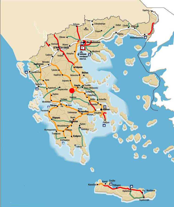
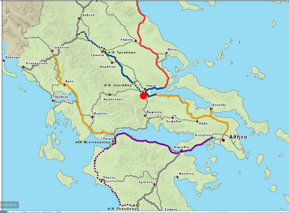
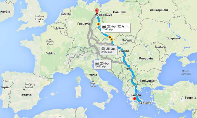
In the center of Greece, in the Entrance of Europe
Close to the capital Athens of Greece
220 kilometers from the capital of Greece Athens Greece (2 hours)
294 kilometers from 2nd largest City of Greece, Thessaloniki (2 hours & 30 minutes )
International & Local Transport and transportation
237 kilometers from Athens International Airport (2 hours & 20 minutes).
8 kilometers from the nearest national railway station Leianokladi
(It is situated at the junction of the main line Athens-Thessaloniki and the branch line to Lamia and Stylida. It is served by intercity trains between Athens and Thessaloniki, and by local trains to Stylida)
227 kilometers from Piraeus International port (2 hours & 20 minutes ).
(The Port of Piraeus is the largest Greek seaport and one of the biggest in the Mediterranean Sea. The Port of Piraeus served as the port of Athens since the ancient times)
27 kilometers from the nearest Port of Stylida.
Stylida or Stylis Port is situated on the north side of Maliakos Kolpos (Gulf). A dredged channel of about ½ mile leads to the basis of the port. The channel is marked at the outer end by pair of light buoys and just before entering the basin by flashing beacons.The maximum draft ffr entering tt channel is 5,80 meter.Stylida Port has three(3) commercial piers of a total lengh 370 meter with the following particulars1st pier 200,0 meter long max draft 5,80 meter2nd pier 100,0 meter long max draft 5,80 meter3rd pier 70,0 meter long max draft 5,00 meter.
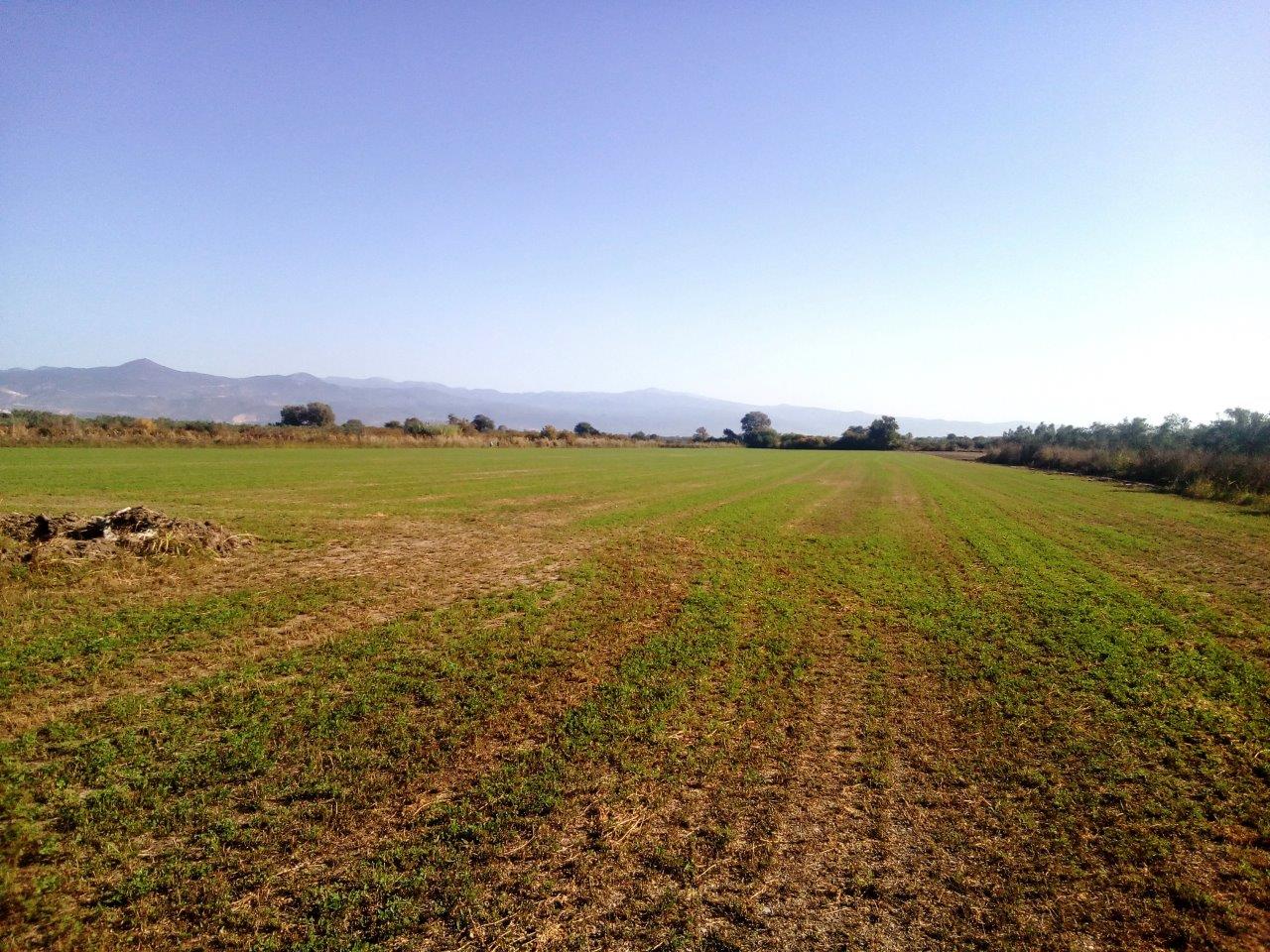
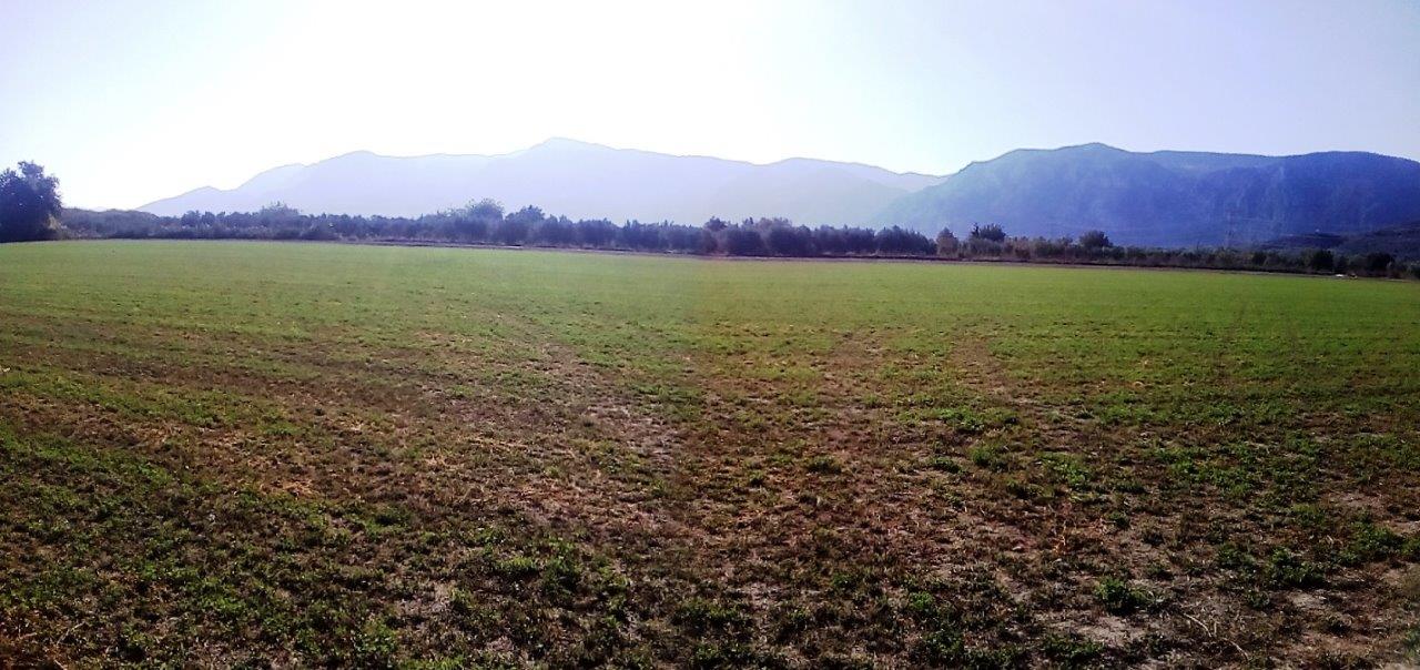
PHOTOS OF OUR LAND


.jpg)
Google earth polygon image with High voltage power pylon points (215 meters frontage on a provincial road)
.jpg)
.png)
.png) Download the Google Earth kmz file
here
Download the Google Earth kmz file
here
TOURISM, ACTIVITIES & HISTORICAL MONUMENTS
Our land is:
Very close to the famous Tourism, historical and natural beautys places in Greece (historical Thermopylae ,Acropolis, Oracle of Delphi, Meteora Rocks, Pilion maountan, Sporades Islands, Parnasos - Velouxi - Pilion Ski senters, etc..).
Is at the foot of beautiful mountain of Oiti
(Oiti is also known as Hercules’ mountain and has a special connection to the mythical hero. There are ruins of an ancient temple that was built in his honour on a small hill at the entrance to Katavothra plateau. According to mythology, at this position known as “Hercules’ Pyre”, Hercules fell into the flames in order to relieve himself from the unbearable pain caused by the robe poisoned with the blood of the Centaur Nessus, which his wife Deianeira had sent him to wear. Philoctetes lit the pyre to burn Hercules, who in turn thanked him by giving him his bow and arrows. According to the myth, Zeus wrapped Hercules in the clouds and raised him to Olympos, where he married the beautiful Hebe, the Goddess of Youth).
Is very close to Oiti mountain Nationa Park
(In 1966, Mount Oeta became the sixth of Greece's national parks in accordance with Royal Decree 218/1966. With an area of 7,000 hectares, of which 3,370 form the core zone and 3,630 the periphery, the park covers approximately one fourth of the mountain's area and is the third largest in Greece. Any human activity that impacts the local environment in whatsoever way is forbidden within the national park's boundaries.The area of the national park has furthermore been declared a Special Area of Conservation as part of the Natura 2000 Network. The Gorgopotamos Gorge has also been declared a SAC, and together with the national park and the Asopos valley forms the broader "Mount Oeta National Park - Asopos Valley" Special Protected Area.Oeta also has two wildlife refuges, where hunting is forbidden: the Skasmeni Frantzi – Dyo Vouna area on the northeastern slopes, and the Oiti–Pavliani area on the southeastern. The national park and protected areas are overseen by the Management Body of Mt Oiti National Park, established as an agency of the Ministry of the Environment in 2002 (Law 3044/2002).
1,5 kilometers from the river Gorgopotamos of Greece (waterfalls, cannoning, relax and traditional food).
(1. In another version of the myth, Zeus cast his lightning bolt and the Gorgopotamos river (ancient Dyras) gushed forth where the lightning struck to cool the burning hero. It is in fact said that the Gorgopotamos river, that supplies water to the city of Lamia, springs from the Katavothra plateau with the spectacular homonymous cavern 2. In World War II mission the British Special Operations Executive (SOE), in cooperation with the Greek Resistance groups ELAS and EDES, which destroyed the heavily guarded Gorgopotamos viaduct in Central Greece on 25 November 1942. This was one of the first major sabotage acts in Axis-occupied Europe, and the beginning of a permanent British involvement with the Greek Resistance).
8 kilometers from the Municipality of the Castle of Lamia
(The location was already fortified in the 5th century BC, according to the findings in the base of the walls of the castle.It is certain that it was in use during the early and middle Byzantine periods.The castle is mentioned for the first time in the beginning of the 13th century, in a letter from Pope Innocent III.In 1218, it was captured by the Byzantines of the Despotate of Epirus under Theodoros Komninos. In 1273, it was given as a dowry to the Burgundian Guillaume de La Roche who later became Duke of Athens (1280-1287).The Francs of the Duchy of Athens were defeated by the troops of the Catalan Company, in the battle of Kopais (1311). After this, the castle remained in the hands of the Catalans until 1446 when it was captured by the Turks.In 1832/33, after the Greek Revolution, the castle was liberated and was used as an army base until World War II).
15 kilometers from historical Thermopylae ***
https://en.wikipedia.org/wiki/Battle_of_Thermopylae
72 kilometers from the historical Delphi's Oracle (1 hour) ***
https://en.wikipedia.org/wiki/Delphi
15 kilometers from thermal springs of Thermopylae, 12 kilometers from thermal springs of kallidromo, 18 kilometers from thermal springs of Loutra Ipatis, 39 kilometers from thermal springs of platystomo, 40 kilometers from thermal springs of Kamena Vourla.
40 kilometers from the seaside town Kamena Vourla (swiiming,nightlife, hotels and tourism area).
48 kilometers from the Port of Agios Konstantinos port (Conected with Sporades Islands).
44 kilometers from the seaside town Raches (swimming, windsurfing, kitesurfing, nightlife).
71 kilometers from Parnassus ski center
91 kilometers from Velouxi ski center
149 kilometers from the mountain Kithaironas (Flyfreedom Paragliding activities).
139 kilometers from the Pillion Mountan (1 hour & 30 min) ***
155 kilometers from the famous Meteora Rocks (Monasteries, climbing) ***
(Beside the Pindos Mountains, in the western region of Thessaly, these unique and enormous columns of rock rise precipitously from the ground. But their unusual form is not easy to explain geologically. They are not volcanic plugs of hard igneous rock typical elsewhere, but the rocks are composed of a mixture of sandstone and conglomerate.The conglomerate was formed of deposits of stone, sand and mud from streams flowing into a delta at the edge of a lake, over millions of years. About 60 million years ago during the Paleogene Period a series of earth movements pushed the seabed upwards, creating a high plateau and causing many vertical fault lines in the thick layer of sandstone. The huge rock pillars were then formed by weathering by water, wind and extremes of temperature on the vertical faults. It is unusual that this conglomerate formation and type of weathering are confined to a relatively localised area within the surrounding mountain formation.This type of rock formation and weathering process has happened in many other places locally and throughout the world, but what makes Meteora's appearance special is firstly the uniformity of the sedimentary rock constituents deposited over millions of years leaving few signs of vertical layering, and secondly the localised abrupt vertical weathering.HistoryAncient HistoryCaves in the vicinity of Metéora were inhabited continuously between 50,000 and 5,000 years ago. The oldest known example of a man-made structure, a stone wall that blocked two-thirds of the entrance to the Theopetra cave, was constructed 23,000 years ago, probably as a barrier against cold winds – the Earth was experiencing an ice age at the time – and many Paleolithic and Neolithic artifacts have been found within the caves.As early as the 11th century, monks occupied the caverns of Meteora. However, monasteries were not built until the 14th century, when the monks sought somewhere to hide in the face of an increasing number of Turkish attacks on Greece. At this time, access to the top was via removable ladders or windlass. Nowadays, getting up is a lot simpler due to steps being carved into the rock during the 1920s. Of the 24 monasteries, only 6 (five male, one female) are still functioning, with each housing less than 10 individuals).
220 kilometers from the capital of Greece Athens Greece and Acropolis (2 hours) ***
309 kilometers from the first capital of Old King of Macedonia of Greece , witch the King Alexander
the Great was born (2 hours & 50 minutes) ***
(Vergina (Greek: Βεργίνα [verˈʝina]) is a small town in northern Greece, part of Veroia municipality in Imathia, Central Macedonia. Vergina was established in 1922 in the context of the population exchanges according to the Treaty of Lausanne, and it was a separate municipality until 2011, when it was merged with Veroia under the Kallikratis Plan. It is now a municipal unit within Veroia, with an area 69.047 km2.Vergina is best known as the site of ancient Aigai (Αἰγαί, latinized Aegae), the first capital of Macedon. It was here in 336 BC that Philip II was assassinated in the theatre and Alexander the Great was proclaimed king. Aigai has been awarded UNESCO World Heritage Site status as "an exceptional testimony to a significant development in European civilization, at the transition from classical city-state to the imperial structure of the Hellenistic and Roman periods".The site was discovered in 1976, and excavated during the 1977/8 season in a campaign led by Manolis Andronikos, which unearthed the burial site of the kings of Macedon, including the tomb of Philip II, father of Alexander the Great which unlike so many other tombs had not been disturbed or looted. It is also the site of an extensive royal palace and of many rich ancient tombs. The objects and paintings found in the tombs at Vergina are of extraordinarily high quality and historical importance. A museum now contains Philip's tomb and a new museum is being[year needed] constructed for the palace and other finds).